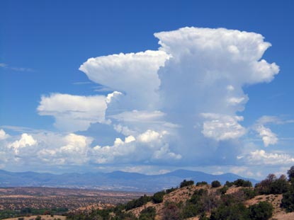
Friday, June 30, 2006

Over the Top


10/05/2004 @ 06:24:24 PM MDT
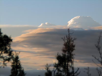
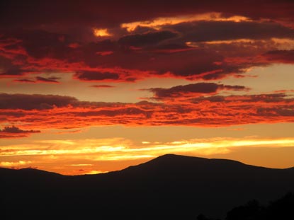
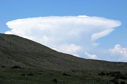
These overshooting tops are a good indication there was severe weather under this storm over Los Alamos, NM.

Thursday, June 29, 2006

An Almost Perfect Day


06/26/2004 @ 10:43:33 AM MDT
This convection was quite vigorous quite early in the day. But without a bit of wind to push the downdraft away from the updraft, these cells quickly drowned themselves and dissipated.

Monday, June 26, 2006

Treasure in the Debris


06/06/2006 @ 08:03:48 PM MDT
The aftermath of daytime heating during the monsoon is what makes New Mexico skies so enchanting. A classically beautiful New Mexico sunset owes its existence to the fact that daytime convection usually breaks up when the heat source is removed. This results in a myriad of different forms of debris clouds. They and the sun are the paint, the sky is the canvas and the painters are the various outflows and air currents.

Most of these photos were taken off my back porch area looking west toward the Jemez mountains and Los Alamos, NM, except where otherwise noted.


06/24/2005 @ 08:11:34 PM MDT


06/14/2005 @ 08:15:21 PM MDT


05/25/2005 @ 08:17:27 PM MDT
This photo was taken just west of Socorro, NM.


04/25/2005 @ 07:39:30 PM MDT


08/06/2004 @ 07:25:48 PM MDT
This is looking southeast toward the Ortiz mountains.


07/10/2004 @ 08:29:48 PM MDT


06/19/2004 @ 08:24:47 PM MDT.


06/19/2004 @ 08:26:04 PM MDT

Camera Failure

I'm deeply regretting not having a working camera at the moment. A beautiful squall line is meandering down the Rio Grande valley, north to south in a huge bow wave, the gust front forming a delicate "s" stretching from the Sangres to the Jemez. It would have been my best capture yet.

Sunday, June 25, 2006

Classic Anvil


07/17/2005 @ 12:38:32 PM MDT
Seen from the Wheeler Peak ridge, north of the peak looking west. I wish I would have climbed to the top of the ridge to get a better shot.

Saturday, June 24, 2006

Weak Convection over the Ortiz


06/24/2006 @ 12:40:25 - 2:49:58 PM MDT
Convection tries to fire over the Ortiz mountains along Highway 14 between Santa Fe and Cedar Crest.

Strong Cells over the Pecos River


06/23/2006 @ 6:40 - 8:19 PM MDT
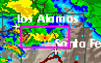
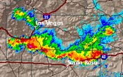
This strong line of cells formed southeast of the Pecos River and eventually stretched all the way to Santa Rosa.

Severe Precip in the Pecos Valley


06/22/2006 @ 4:13:09 PM MDT
I rushed toward Las Vegas at about 3:00 PM on June 22, 2006 when I saw the severe thunderstorm warning boxes go up on FDX. There were two cells forming. I stopped about 10 miles south of Las Vegas on northbound I-25 and watched the more northerly cell. Not much happened there. Meanwhile, the cell I passed starting going off. I turned around and headed back through the precip shaft. It seemed like it was falling at a rate well over three inches per hour with some nickel-sized hail.

Friday, June 23, 2006

Clouds of the Beast?


06/06/2006 @ Appx. 5:30 - 6:00 PM MDT
Leaving work at 5:00 on June 6, 2006, I immediately noticed a circular-looking structure I thought might be a wall cloud. I rushed home and made this short time-lapse movie which shows some rotation. But Keith Hayes at NWS ABQ explained why it was more likely outflow turbulence:
Overall the atmospheric conditions yesterday were not favorable to producing a deep layer mesocyclone or rotating updraft. Generally the convection that supports a mesocyclone is many thousands of feet thick (typically 20,000+), but more importantly we have to have a strongly sheared vertical wind profile (the winds both change in direction clockwise and increase in speed with height).

Yesterday's situation favored elevated or high based and rather shallow convection and this can often lead to very turbulent situations and lots of swirling cloud. The vertical wind profile was rather disorganized (wind directions and speed were not consistent with height) and not a model for the classical mesocyclone signature profile.

Los Alamos Under A Fairy Curtain


06/09/2006 @ 7:02:56 PM MDT
I'm not sure if this is light precip or an extension of the clouds.

Being Enchanted by the Skies of Northern NM


11/15/2003 @ Appx. 11:30 AM MST
Three years ago, I ended up renting a small adobe home with a million dollar view near Santa Fe, New Mexico. Since a young age I've been inordinately fascinated by the weather. 20 years in California dulled the jones, but moving to New Mexico brought it back with a vengeance. My recent purchase of a camera with an intervalometer and my joining the ranks of SKYWARN weather spotters has sealed my fate as an unrepentant weather geek. I'll post photos, time-lapse movies and video of the weather and also some of the sunsets over the Jemez mountains as I encounter them.