Temperature data patterns create blooming flower
posted by guruphiliac @ 3:41 PM
0 comments
![]()
posted by guruphiliac @ 3:41 PM
0 comments
![]()
 On Sunday, March 31, 2013, I got a chance to do a little storm chasing in California. While the convection coming off the Diablo range near Tracy, CA never really got organized while I was out there, I did manage to observe rain rates in excess of 1" per hour along with a few dime-sized hail stones as well as some accumulation of pea-sized hail on the road.
posted by guruphiliac @ 11:27 AM
0 comments
![]()
posted by guruphiliac @ 8:53 PM
0 comments
![]()
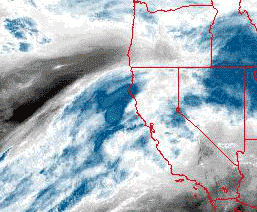
 The rain gauge hasn't tipped yet, but today we were visited by subtropical moisture in a rare monsoon event. The image above shows the effect of the orographic lift provided by the Santa Cruz Mountains.
posted by guruphiliac @ 7:53 PM
0 comments
![]()
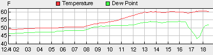
 Finally got my Davis Vantage Pro2 talking to this web page once again. As you can see by the siting, don't expect any good wind data. However, temperature, humidity, and barometer readings are all good for Redwood City near San Carlos, CA.
posted by guruphiliac @ 8:03 AM
0 comments
![]()


![]()